[for assignment instructions,
click here]
4. Creation of Raster geology file from ESRI Shapefile
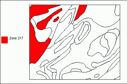
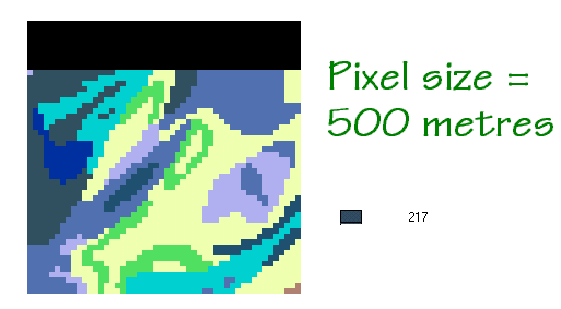
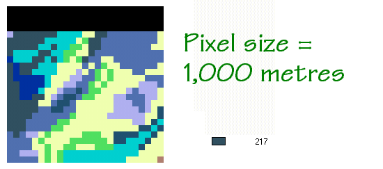
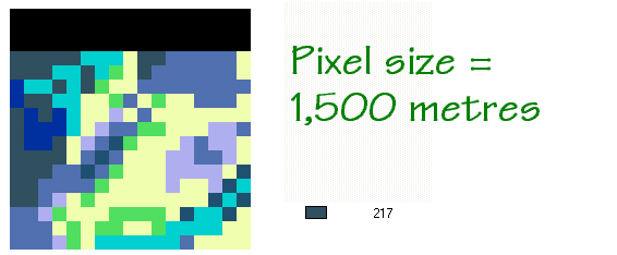
From geol.zip, the ESRI shapefile was converted into an IDRISI vector file, which was then rasterised with extents such that a rectangle stretching approximately 25 km east/west and 21 km north/south could be mapped. (NOTE: this rectangle appears to be somewhere in the North Sea between Norway and England). However, the rasterisation process was performed at 6 different cell resolutions, to analyse the effect of cell resolution upon accuracy of ground measurements. (NOTE: while the term "higher" or "increased" resolution generally means that a given pixel depicts a smaller ground area, for the purposes of this assignment, I will refer to increasing resolution as going to larger pixel sizes; a 1,500 metre pixel represents an increase in resolution from a 1,000 metre pixel, for instance)
Using these 6 different raster images, the IDRISI AREA module was run to calculate the total map area (in metres² and in number of cells) for a particular geology zone, #217. These resulting data were then assembled into a spreadsheet so that the resulting area figures could be compared with the actual known area of zone #217, and graphs could be produced.
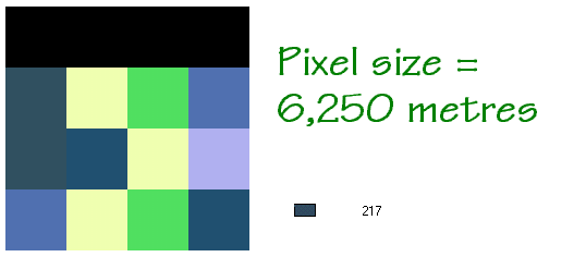
While 1500 metres was the largest pixel size asked for in the assignment, I decided to take the analysis to an "extreme", to help me expand my perspective of IDRISI's capabilities. I decided to create a 6th image where the grid consisted only of 4 rows and 4 columns. The resolution at this density was 6,250 metres per pixel. It is so "coarse", that zone #217 comprises only 2 pixels!
a) For the table and
graph of Area Error vs. Pixel Size , click here.
b) For the table and
graph of File Size vs. Pixel Size , click
here.
Comments
Trade-offs are important considerations in creating raster maps. Larger pixel sizes mean fewer columns and rows to show a given image. This is demonstrated in the following images:
But this isn't always the case. The first conclusion from analysing the error data shown in 4.(a) above is that, while error generally increases as pixel size increases, it sometimes decreases too! This seems totally unexpected at first. Upon looking at some of the above images, though, it seems that there are "quantum" jumps in the number of pixels that are chosen to be within a given polygon. The area of zone #217 in metres² sometimes increases, sometimes decreases, even though resolution is increasing. This occurs because, while the number of pixels decreases, the area per pixel is increasing in fairly large "chunks" or quanta. There appears to be a bit of a randomness to this "swing" above and below the actual area, though the trend is overall towards less accuracy with increasing pixel size.
One very surprising finding was that the resolution of 6,250 metres, while at first seeming ridiculously too large, produces a value (70,000,000 metres²) that is not that far off from the actual area of 67,305,367 metres². In fact, if the client were satisfied to round the measurement to the nearest million, the measurement at 6,250 metres resolution would be 100% correct! Obviously, though, this is contingent upon the fact that zone #217 is fairly large; were this exercise to have been conducted upon a very small zone, the 6,250 resolution may not have chosen any pixels.
It also seems to depend upon the shape of certain polygons; if a polygon is long and narrow, for instance, and one increases the resolution, a polygon that showed up at 1,000 metres may not show up at 1,500 metres. This occurs because of IDRISI's decision-making convention in the POLYRAS module as explained in Question 3.(b); that is, the pixel must be completely within a vector polygon in the vector-to-raster process to be chosen.
In conclusion, while it appears that the most accurate analysis results from the highest number of pixels per image, there is a certain "threshold" image density above which the marginal increase in accuracy is not worth the marginal increase in cost. To try and quantify this, I created a concept of "indices" to try and rank the 5 different resolutions and decide on the optimal one. These ranks are based on the following assumption:
Your comments on this assignment are welcome!