VECTOR-TO-RASTER
conversion of Housing Market Data :
Vector GIS is often
used to define the urban geographic surface by points, lines and polygons,
on the assumption that business-geographic information is commonly collected
and analysed that way. Each place on the earth's surface can lie
on or near a point (eg: a city, an apartment building), on or near
a line (eg: a street) and/or within a polygon (eg: a census
tract, or rental market zone). Each of these vector entities have
attributes (eg: street address, average rent, vacancy, hydro expense) associated
with them, stored in a database that is linked to the geographic objects.
A rental market zone, as a GIS polygon, can itself have attributes associated
with it, such as the "average rent" taken from all the apartment buildings
(points, with rent as their individual attributes) within that polygon,
or rental market zone.
Raster GIS defines
the geographic surface as rows and columns of pixels. There are no
points, lines or polygons. Instead, think of the earth's surface
as a giant "spreadsheet", of columns and rows. Each "cell" on that
spreadsheet (or "pixel" in the raster GIS image) has an address, such as
"D41" and contains a single bit of information, such as telephone expense.
Each cell is exactly the same size, and no part of the spreadsheet is without
a cell, even though many may be empty.
A raster GIS represents
the earth's surface the same way. Instead of rental market zones
as polygons in a vector GIS, the metropolitan area is now a "sea" of pixels,
each of which stores a value for rent, each of which can be referenced
in the way a cell in a spreadsheet can.
A vector entity,
such as a point representing an apartment building, or a polygon representing
an rental market zone, can have numerous attributes associate with it.
For instance, clicking on rental market zone 5 in Calgary's vector GIS
can bring up the average one-bedroom rent of the past 6 years and the current
growth rate of rental households in it.
Each raster GIS pixel,
on the other hand, stores only one value. It may be rent, it may
be population growth rate. However, that value can be manipulated,
re-calculated analysed, summarised, etc. As well, one raster image
storing rent information can be overlain onto another of the same rental
market zone storing population information, to satisfy "IF-THEN" types
of queries (these are known as "Boolean overlays", since they use standard
Boolean algebraic logic equations). One can isolate neighbourhoods
where both the rent and population are dropping most rapidly, for example.
Certainly this is also possible in a vector GIS, but with not nearly the
same level of accuracy nor simplicity.
In fact, one major
advantage of raster GIS is that it lends itself to complex mathematical
analysis not possible in vector GIS. For instance, trend surface
polynomial expressions can be calculated (ie: multiple regression equations,
where the independent variables are latitude & longitude, a common
tool in economic geography) that allow one to create models of geographic
behaviour, and predict unknown values based on known inputs.
The images below
demonstrate how rent may be stored in a raster GIS. They were derived
first by address-geo-coding a Lotus 123 spreadsheet, containing the addresses
of apartment buildings in a Canadian city, with the year they were built
and their rents, onto a street-network file (SNF), in MapInfo. Next,
an SQL query was used to isolate one-bedroom rents in buildings constructed
between 1960 and 1970. The following steps describe the hybrid process
of vector-to-raster conversion :
-
MapInfo .TAB
file, representing apartment buildings with one-bedroom rents as the only
attribute, converted to ArcView .SHP (shapefile), point-format;
-
ArcView .SHP
file imported into IDRISI .VEC file format (IDRISI is a standard
raster GIS package), a raster-readable vector file;
-
IDRISI .VEC file
interpolated, using "Inverse-Distance Weighting" (distance exponent, Dn,
n = 1.2, considerably less than standard value of 2, ie: "D-squared"),
to an IDRISI .IMG true raster file.
resulting in a continuous
surface of average rent. The following images illustrate this step
by step evolution from vector to raster.
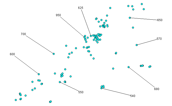
This is the "source"
vector
point data. Note the sample of average one-bedroom rents associated
with different apartment buildings.
 |
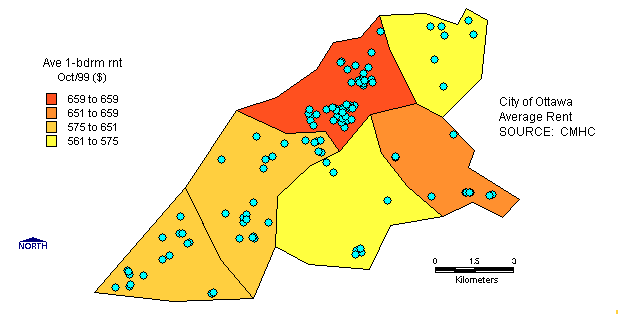
The
next image represents one way that the above vector point data may be represented
by vector polygons:
 |
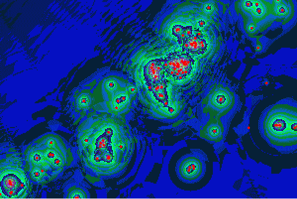
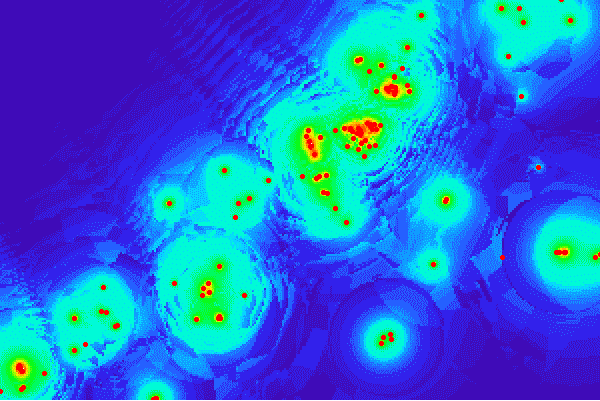
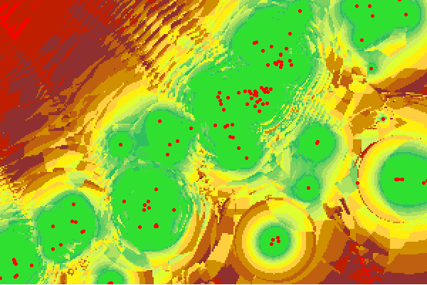
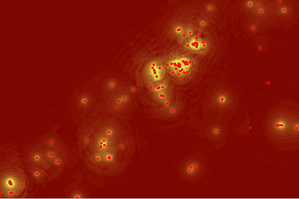
The
following 4 images represent different possible raster GIS images
resulting from interpolating the above vector point data. The apartment
buildings (vector points) from the 1st image above, as "source" data, are
overlain to give perspective. Each of these images contain ~60,000
pixels, and each pixel has with a "rent" value associated with it:
 |
 |
 |
 |
Your comments
on this page are welcome!
Back
to Contents