(NOTE: This was not
an Algonquin course assignment, but, rather, one of my personal projects.)
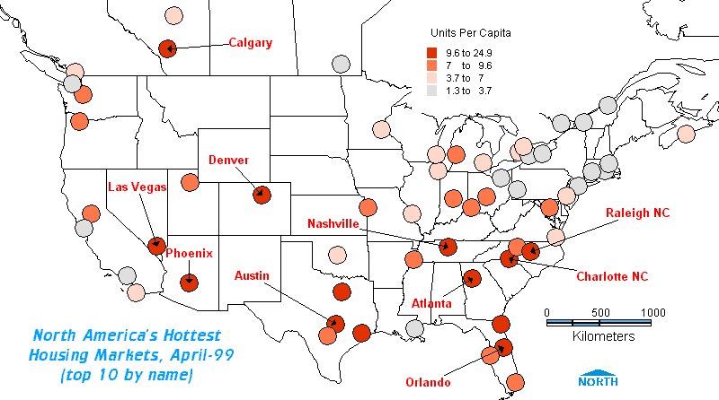
Shading polygons (eg: states or provinces) with a chromatic theme where the colours correlate to size-classes based on the numeric range of your data is one thing. What happens when, rather than polygons, you have points to map?
Such is the case when you wish to portray city data. Examples may include sales/inventory data for your warehouse operations. Or crime-rates, average income, even "physical geography" data, such as "days-of-sunshine". In this case, it is new house construction, or housing starts.
In "topology" theory, a point is infinitesimally small; it has no dimension. An arc has length and direction, a polygon has area, perimeter, number of points, etc. But a point? Now, there is of course the basic topology characteristics of a point that it shares with arcs and polygons, namely, its relationship to other topological features (ie: "left polygon / right polygon", "to/from"), if it is part of other arcs or polygons. That is, if it is a node.
That's the problem you get when your points are cities. They basically sit there in space! They are not connected to arcs (unless you plot roads), nor polygons (unless you plot county or municipal boundaries ... but then they become polygons and are no longer points, are they?!), so they are not nodes. They do, however, have spatial, X-Y co-ordinates.
So how do you create a thematic map of point data? Basically, you end up creating circles as "quasi-polygons" (a circle for each city, for instance). MapInfo and ArcView give you a wide range of options in this case, and I've just started working with MS MapPoint 2000 which also provides this function (though I still have not figured out how to show 2 themes in MapPoint - help!). You can do this in 2 ways:
SOURCES: Canada Mortgage
and Housing Corporation (total starts, January to April)
US Department of Commerce (total building permits, January to April)
PS: I'm not entirely happy with the projection above, but it required blending a map of Canada with one of the US, a bit of a challenge on which projection to use. I generally like UTM, but my "create points" sub-routine in MapInfo was based on latitude and longitude, so UTM co-ordinates were out.
Your comments on these maps are welcome!