[for assignment instructions,
click here]
1. File Size
The maximum value in MAXHOT.IMG
is 442. Certainly this is not 442°C! The documentation
file indicates that the "units" are actually increments of 1/10 of a degree
Celsius, but the data-type is integer; 2 bytes per pixel.
Alternatively, the increments could have been in 1 degree Celsius, the
maximum value then being 44.2, but this would require that MAXHOT.IMG be
real
data-type, requiring 4 bytes per pixel. Thus, to display the data
in a more "user-friendly" manner, such that the client is not forced to
mentally divide the values shown on cursor inquiry by 10, would double
the file size, from 411K to 822K. A trade-off is made, where file
size is minimised, but presentation of map data is less than ideal.
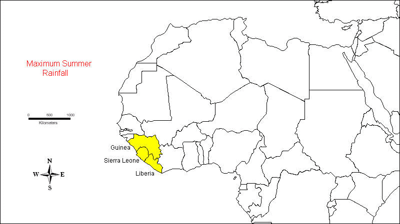
2. Highest Summer Precipitation
The following co-ordinates outline a polygon where summer precipitation is highest in Africa, near the country of Sierra Leone:
Longitude
Latitude
------------
------------
16.49° W
5.76° N
17.16° W
11.94° N
12.82° W
11.77° N
7.47° W
4.26° N
16.49° W
5.76° N
CLick here
for an image showing this location.
3. Maximum Summer Precipitation Values
The maximum value of summer
precipitation is found in Sierra Leone, 363.7 cm. The
top 3 African countries ranked by maximum summer precipitation are illustrated
in this map.
4. Average Summer Precipitation Values
The top three countries in terms of highest average summer precipitation are:
5. Ratio
We have to add "1" because
many pixels have the value zero. This is especially important for
NOVAPRPR.IMG because that image is the denominator in the <OVERLAY>
module, and this would result in "division-by-zero" if we did not add "1".
6. Table 5: Range of Values in RATIO image
Hemisphere
--------------
Northern
Southern
-----------------------------------------
Rainfall Regime
--------------------------------------------------------------------------
Summer
z > 1.3
z < 0.76923
Winter
z < 0.76923
z > 1.3
Uniform 0.76923
< z < 1.3 0.76923 < z < 1.3
7. Positive/Negative
All values in the north are
positive, in the south are negative (equator was found at rows 227/228).
This method would not be appropriate if RATIO.IMG had positive
and negative values in both hemispheres because it is through the negative
values that we can separate the hemispheres for analysis purposes.
Negative values in the North would remain negative after multiplication
with CHANGER.IMG, leading to incorrectly classifying some North values
as South.
8. Minimum/Maximum
The minimum value of NSRATIO.IMG
was -4.6885247, the maximum was 416.0; interestingly, while the maximum
of RATIO.IMG was also 416.0, the minimum of RATIO.IMG was 0.0041152 --
how can this be? What this indicates is that a ratio of +4.6885247
was actually the maximum of RATIO south of the equator.
However, it's presence was "buried" by the wide range of data in the total
image because, for all of Africa (positive data) the maximum is 416.0,
and the <DESCRIBE> module can only cover an entire image, not a partial
image.
9. Comments on the distribution of Regimes
Most African countries display a summer regime -- most rainfall occurs in a given hemisphere when that hemisphere is tilted toward the sun. This is expected because, with some exceptions, one expects more evapo-transpiration during hotter months, leading to higher relative humidity and, subsequently, more rainfall.
The notable exception is
along the Mediterranean coast of Africa, where a winter regime predominates
-- this is the classic "mediterranean" climate involving wet winters (characteristic
of California as well).
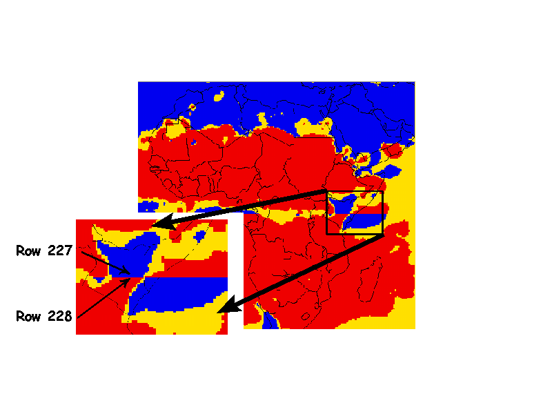
10. Equator Shift
Along the equator (click here for map), there seems to be an artificial "quantum" change in regime classification, where the regime switches between summer/winter along a perfectly straight line. However, "Mother Nature" does not recognise the artificial constructs of man. The particular micro-climate along a small section of the equator, or any lines of latitude for that matter, is probably the same several kilometres to the north of the equator as it is to the same distance south of that line. In fact, using RATIO.IMG, in north-western Zaire, a ratio of 1.042701 was found for a pixel just north of the equator (col=240, row-227), and exactly the same ratio was found for a pixel just south of the equator (col=240, row=228), several kilometres away.
It is Man, however, who classifies the seasonal shift, based on tilt of the earth. Making 1.042701 negative to the south of an artificial line on the globe may change the category that pixel is placed in, but it does not change the fact that vegetation in that pixel experiences the same pattern of precipitation as vegetation several kilometres to the north.
In order to avoid this "quantum
leap" in classification, one could use the <FUZZY> module as a decision-making
tool, using a probability function along the equator where classification
is 100% at the equator, and drops off exponentially to 0% to a point, say,
50 kilometres on either side of the equator.
11. Boolean Questions
No, the existence of 1's
and 0's does not necessarily mean that <RECLASS> was run correctly.
An error might occur simply because there are no data in certain areas,
which a Boolean operator treats as 0. For instance, in ANNPRR.IMG,
"no data" would be classed as 0, since we are looking for values between
700 and 2500 (cm.), yet those pixels could in fact be part of the suitable
area, and thus, should have values of 1.
12. Choice of Overlay
Multiplication
is the <OVERLAY> module option, because the Boolean operator is "AND"
in the Venn diagram. That is, all conditions must be
satisfied, not just 1 or 2. Thus, if a given pixel has a value of
1 in image A, but a value of 0 in image B (ie: it "fails" in at least one
image), then 1 * 0 = 0, and the pixel is thus excluded from suitability.
13. Largest area of land suitable for Eucalyptus
Angola, with 2,276 pixels
having a value of "1" in SUITABLE.IMG, has the largest area. This
equates to approximately 718,000 square kilometres, given the image resolution.
14. EXTRACT module statistic
For question 13, the summary-type is "total". Pixel values of 1 constitute suitable areas, so one is really trying to count the number of pixels with "suitable values". A sum of 2276.000000 for pixel values actually means that 2,276 pixels have a value of 1, since any pixel with a value >0 has a value exactly equal to 1, so 2276.000000 / 1 = 2276 pixels.
It may appear that one could
use the <EXTRACT> summary-type of "average". However, since all
pixels have values of only 0 or 1, the average value for each country would
be between 0 and 1. A high "average" value (eg: Swaziland) could
simply indicate very few pixels with a value of 0, not necessarily a lot
of pixels with a value of 1.
15. NDVI analysis
AFTOT88.IMG was processed with <EXTRACT>, summary-type of "average", using REGIMES.IMG as the feature definition image. The following table illustrates the results:
Rainfall Regime
Average NDVI value
---------------------------------------------------
Winter
495.045557
Uniform
409.341598
Summer
682.353325
There is indeed a difference in NDVI statistics between regimes, and this is entirely expected. NDVI pixel values are an indicator of the type of vegetation on the ground, based on reflectance values as determined by the amount of chlorophyl in plants. Different vegetation "regimes" or categories would be a function of different rainfall regimes. That is, the vegetation would be an "dependant variable" and rainfall regime would be an "independent variable" were one to develop a regression model.
Indeed, this is the whole basis of this exercise, because an assumption is made that eucalyptus plants are sensitive to a particular rainfall regime, amongst other factors.
Your comments on this assignment are welcome!